Introduction
Google Earth historical Street View, which first launched on June 10, 2005, celebrates its 20th anniversary by letting users travel through time and space in a whole new way. The spotlight feature is historical Street View imagery, now integrated into Earth alongside traditional satellite layers. For Earth Pro users, Google will soon roll out Gemini AI-powered environmental insights, providing valuable data like tree canopy coverage and land surface temperature.

Street View Time Travel Comes to Earth
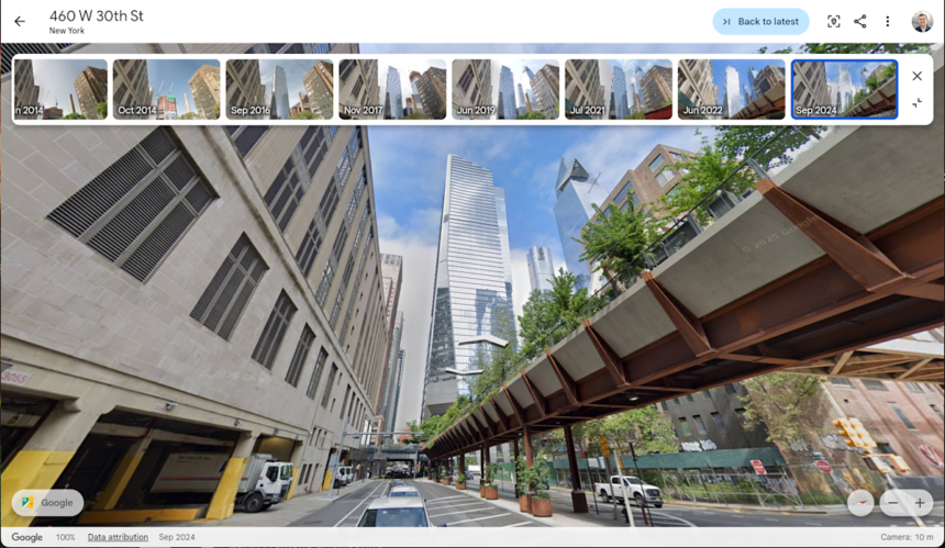
Previously available in Google Earth historical Street View Maps since September 2024, historical Street View lets users dial into snapshots from different years. Starting June 24, 2025, this feature is now available in Google Earth’s desktop and web apps .
- How it works: Enable “Historical imagery” in the Layers menu and select Street View. Then scroll through a timeline to revisit past scenes .
- Why it’s useful: Handy for seeing urban development, infrastructure growth, green space changes—or reliving childhood streets .
- Timelapse & nostalgia: Popular hashtags like #somewhereonGoogleMaps reflect the crowdsourcing trend of rediscovering lives and changes online .
Gemini AI Insights for Earth Pro

Earth Pro users will get more than time travel—they’ll soon access cutting-edge AI to analyze geospatial data:
- Tree canopy coverage: Visual heatmaps generated by AI to identify shaded versus exposed zones—critical for urban forestry and CO₂ offset projects .
- Land surface temperature: Heat mapping tools to locate urban heat islands—aids city planning, climate adaptation, and public health initiatives Google Earth historical Street View.
- Natural language queries: Ask questions like “Which areas have low tree cover?” or “Highlight hottest zones” and receive instant AI-powered overlays .
These tools help professionals analyze data at the click of a button, reducing manual surveying from days to minutes Google Earth historical Street View.
Why This Matters
This launch has broad implications across sectors:

- Environmental scientists: Monitor deforestation, lake shrinkage, or recovery post-natural disasters over decades.
- Urban planners: Identify uneven green coverage or regions with thermal stress to make data-driven decisions.
- Educators & public: Visualize history—cities, landmarks, and personal memories come alive again.
- Heritage & research: Witness cultural heritage transitioning as buildings evolve or disappear.
20 Years of Google Earth Evolution
Since its launch in 2005—when it garnered 100 million downloads within the first week—Google Earth has been a pioneer in 3D mapping . Over the past 20 years, key milestones include:
- 2008: Fully integrated Street View panoramas .
- 2017: Earth Timelapse debuted, offering satellite change visuals across 38 years.
- 2024: Historical aerial imagery became accessible across platforms.
- 2025: Historical Street View and Gemini AI launch push Earth into the next generation.
Today, Earth processes billions of imagery tiles and witnessed 2 billion place searches in the last year alone .
How to Access the New Features
- Historical Street View: Go to Earth → Layers → activate “Historical imagery,” switch Street View, and scroll the date slider.
- AI insights: Available to Earth Pro users in select regions—update to the latest version in the coming weeks.
- Explore more: Visit Earth’s 20th anniversary blog and check the #onEarth initiative for project showcases.
Conclusion
With the launch of historical Street View imagery and Gemini AI insights, Google Earth transforms from a mapping tool into a powerful time machine and analytical platform. Whether you’re exploring personal history, conducting environmental research, or making smarter city plans, these features offer unprecedented perspective and data—all in one globe-spanning app.
Explore Google Maps AI enhancements → Google Maps AI enhancements
External References:
- The Verge – Historical Street View for Earth
- TechCrunch – AI-driven insights details
- Tom’s Guide – Pro tools for planning


