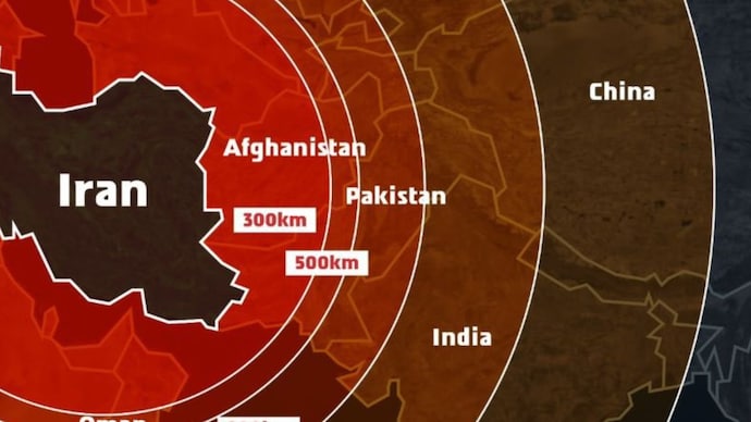
In a serious diplomatic misstep, the Israel Defense Forces (IDF) found itself in hot water after releasing a missile range map amid escalating tensions with Iran. The image showed Jammu and Kashmir (J&K) as part of Pakistan and **Northeast India as part of Nepal**, triggering a massive backlash across India. The controversy has become a trending topic globally under the hashtag #IsraelMapBlunder.

📍 The Error That Sparked Diplomatic Embarrassment
The disputed map was posted as part of Israel’s media campaign justifying its surprise military operation titled Operation Rising Lion, a powerful strike against Iranian nuclear infrastructure. The map included nations in the range of Iranian ballistic missiles—including India—but inaccurately displayed critical Indian territories.
In particular:

- J&K was labeled as Pakistan-administered territory
- Arunachal Pradesh and parts of Northeast India were shown as Nepalese territory
The post, captioned “Iran is a global threat,” drew sharp reactions from Indian citizens, journalists, and geopolitical analysts. It overshadowed Israel’s intended message and stirred a heated diplomatic moment.
🧭 IDF’s Response and Public Apology
Responding to the outrage, the Israeli military acknowledged the mistake via a social media platform, stating:
“This post is an illustration of the region. This map fails to precisely depict borders. We apologise for any offence caused by this image.”
But for many Indians, the apology was too little, too late.
🇮🇳 Indian Netizens and Officials React
The image drew criticism from users on X (formerly Twitter). One community note stated:
“The Union Territory of Jammu & Kashmir and Ladakh, along with the states of Sikkim and Arunachal Pradesh, are unquestionably integral parts of sovereign India.”
Calls for a formal diplomatic explanation flooded social platforms. While there’s no official statement yet from the Indian Ministry of External Affairs, sources report informal communications have been exchanged through diplomatic backchannels.
🌐 Why This Matters

India has always maintained a firm stance on its territorial integrity. The depiction of Indian territories incorrectly—especially by a close defense ally like Israel—can have long-term repercussions if not handled delicately.
Furthermore, this comes at a time when India-Israel relations are strong, with defense cooperation, intelligence sharing, and tech collaboration at their peak. Such errors, if recurring, can strain the sentiment around this strategic partnership.
🌍 The Bigger Picture: Iran, Missiles, and Global Tensions
The map was part of a broader communication piece emphasizing the range of Iranian missiles following retaliatory attacks by Israel on Tehran. According to the IDF, over 15 countries, including India, Russia, and Ukraine, fall within Iran’s missile capabilities. That message, however, was quickly drowned out by the cartographic controversy.
📎 External References and Sources
- India Today: Israel apologises for map showing J&K as part of Pakistan
- Israel–India Relations – Wikipedia
🔁 Internal Reads You Shouldn’t Miss
- Operation Rising Lion: Israel Strikes Iran’s Nuclear Sites
- India’s Response to Map Misrepresentation Incidents
- What Is the Begin Doctrine and Why It Still Matters
📌 Conclusion
The Israel map blunder may have been unintentional, but in geopolitics, even illustrations carry weight. As Israel battles Iran militarily, it now also navigates the sensitivities of key global partners. This incident is a reminder: in diplomacy, details matter.
👉 Stay informed: Subscribe to our newsletter for in-depth analysis and breaking global developments.


